Robberg Peninsula Hike in Plettenberg Bay – A Garden Route Adventure – Where to Stay
This trail is one of the most beautiful hikes we have done, with constantly changing terrain along cliffs, seal colonies, boulders, sand dunes, beaches, and an island where the ocean curves around it. We spent more time than just hiking, simply taking in the beauty of this place.
We also share below where we stayed along the route and why these accommodations were perfect for our journey.
Sunrise and Start
We set out early to catch the sunrise, reaching Robberg Nature Reserve just in time to watch the sun rise (at 6.57 AM the day we went in late August) beautifully over the Outeniqua Mountains. It took about 5 mins from where we stayed to get there. The parking for the Robberg Penninsula is right at the entrance and since we were the first one to be there, it was all empty. After parking we got our tickets and waited outside the entrance to get the view of the sunrise. Then we entered the reserve and they had a map at the entrance.
We noticed, the reserve offers three trails of different length. They are like loop trails starting and ending at the same point. We chose the Point Circuit which is about 9.2 km. The Point Circuit is the route that goes all the way around the Robberg Peninsula to the tip of the peninsula and returns back. We wanted to have a full experience walking around the penninsula and later we realized this full loop of 9.2 kms is a must do as the terrain changes constantly in this trail and we got to see the ocean, walk on ocean side cliffs, climb up and down large boulders, climb large sandunes, hike an island, visit a doube sided beach and more.

The sun rising from behind the Outeniqua mountains

Morning sun rays hitting Robberg Beach
We started the Point Circuit clockwise, we immediately had breathtaking aerial views of Robberg Beach and we kept walking. A few minutes later, we came across a viewpoint platform from where we had a beautiful view of the ocean in front of us, and Nelson Bay Beach and Robberg Beach behind us. The trail along the cliff edge gave a perfect introduction to the hike with the Indian Ocean sparkling below.

Blue Planet Travellers
Nelson Beach on the left and Robberg Beach on the right
The late August weather was perfect with warm sun and a light breeze cooling us occasionally. We felt comfortable with our windbreakers, neither felt hot nor cold.

View of the Indian ocean from the trail 80 metres above
Seal Colonies
As we continued, we passed massive flat rocks all the way down hosting seal colonies. We were about 80 – 90 metres up on the trail and we still could smell and hear the seals from below. We stood there and watched the seals rest, fight, and leap into the water. Definitely not an everyday thing to stumble upon. Until this point, the trail ran along the edge of the cliff, offering a vertical view down to the ocean.

Spotted the first seal colony 80 meters below
We later passed by the lighthouse, and the rocky trail turned to soft sandy beach lined with green bushes. Here, the trail moved away from the cliff edge, sitting roughly a metre inland. We could see the tip of the Robberg Penninsula from here as the mountain started curving to a point.
In about an hour and a half we reached the tip of the peninsula. There was a bench there at the tip with the view of the ocean to its front and the lighthouse on top of the mountain right behind us. From this viewpoint, the Indian Ocean stretched all the way to the horizon, and we could see seals and dolphins down below along the cliffs, almost 70 meters down. We sat there to watch them for a while and moved on.

Cormorants resting on the rocks as the waves crash around them

Boulders and the Point
From the tip, the trail turned back, and we descended large boulders toward the official Point of the peninsula.
The sign board for the Point was down the mountain.
Climbing up and down the boulders, we stayed close to the ocean, with waves crashing against the boulders, making the trek thrilling and immersive. We had the Penninsula to our right and the Indian Ocean to our left and the trail here was the narrow stretch of land with so many boulders in the path. As it is not possible to have a clear trail on the boulders, there were several flags that popped from in between the boulders and served as the trail. We walked from flag to flag, one after the other, many times, climbing over huge boulders along the way.
Once we crossed the boulders, we had to climb a series of staircase and climb another one down, As a large boulder stood between the mountain and the ocean the staircase was built to go over the boulder.

Between the waves and the peaks – our boulder walk
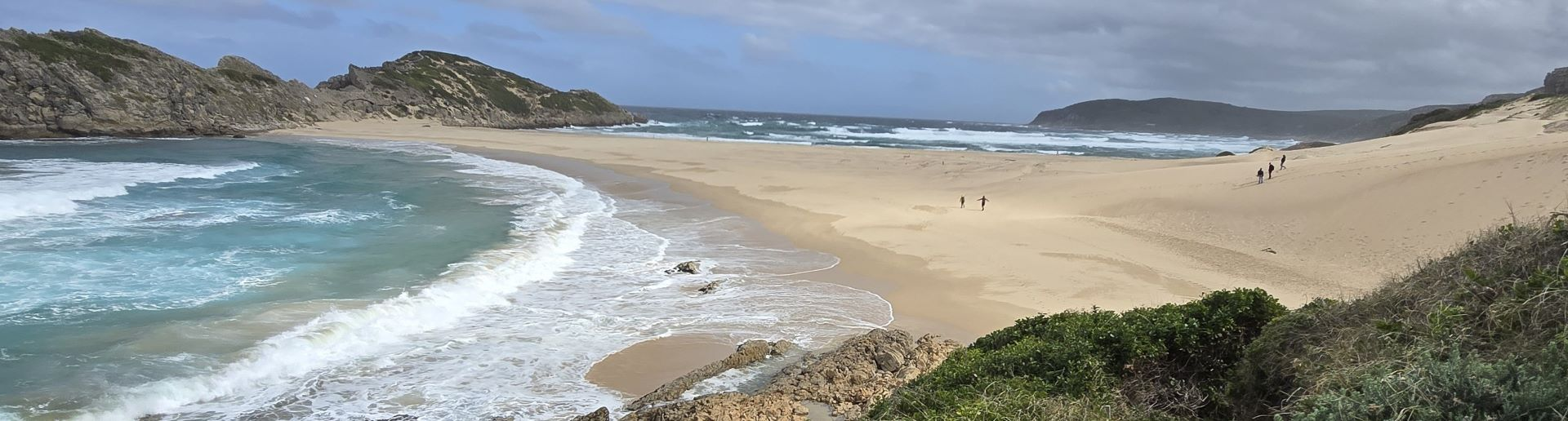
Sand Dunes and Island
After a short walk from here, and we reached Witsand dune overlooking a double-sided beach and the island.
The sand dune itself was massive, far larger than we had expected. The ocean curves around the island, creating two distinct beaches. We sat on the dunes for lunch, with the view of the Island. Then we walked onto the island to get a view of the ocean and the Sandune from above.

Trail leading to the sandune, double sided beach and the island.

Seagulls waited, hoping to get a bite of our lunch.

The Island
We were curious to see if the waves from both sides of the ocean meet and waited on the island. At around 1:45pm a large wave from the left side merged with the ocean to the right. A hurray moment for us.

View from the Island, double sided beach and the Sandune
Wildlife and Return

Tiny dune hill in front of the big sanddune
On the return, the trail continued along narrow cliff paths where ocean waves occasionally splashed us.

The trail along the coast- Robberg Penninsula
Along the way, we observed kelp gulls, cormorants and other coastal birds, adding to the vibrant atmosphere of the peninsula.
We highly recommend hiking this Robberg Penninsula. Not to be missed if you happen to be in the Garden Route.
Where we stayed
Plettenberg Bay – Best View @ No 2
Best View @ No 2 was perfectly located near Robberg Beach with amazing beach views, walkable to Robberg Beach and just a 5-minute drive to the Robberg Peninsula trail and on the main street with great restaurants. This apartment (acrtually extemely large three bedroom with kitchen and huge living area) can easily hold 5 to 6 people and if you are a large group this place is a deal. It felt like home.
Knysna – Falcons View Manor
If you are driving from Knysna this is a place we recommend.
Falcons View Manor offered stunning views, incredible staff, and a flawless stay, everything was perfect!
Tips for Hiking Robberg Penninsula
Plettenberg Bay is the closest town to hike Robberg Penninsula.
Entrance fee
R65 per adult, R45 per child. Tickets can be purchased at the entrance of Robberg Nature Reserve, the office was opens at 7:00 AM. The trail starts at the entrance.
August is peak season, with the weather perfect for the hike. The hike takes about 4 hours.
Do the hike clockwise
Some parts of the trail (especially at the beginning) is narrow and steep, and hiking the popular clockwise direction helps you navigate past other hikers without difficulty.
Start Early
Start early between 6 and 7 AM as the seals are still in their colony. As the day pass they jump into the water to cool them down and not much visible. The waves also get rough along the path.
Leave a Reply