Trekking Laguna de los Tres – An adventurous and challenging Single-Day Trek in Patagonia Argentina
Laguna de los Tres translates to Lake of the three in English. The name refers to the three prominent peaks that tower over the lake in Argentina’s Los Glaciares National Park: Mount Fitz Roy, Poincenot, and Saint-Exupery, The Laguna de los Tres trek ends with a breathtaking view of Mount Fitz Roy.

Blue Planet Travellers
Ticket office at the entrance of the trail

Blue Planet Travellers
Several hiking routes in Patagonia. Laguna de los Tres – follow the orange and red one
We started our hike to Laguna de los Tres at 9 AM, driving from El Calafate, which is about a 3-hour drive. The hike itself is about 22 km round trip hike to Laguna de los Tres. The beginning of the trail was gentle, a slight uphill through the mountains for about 1.5 hours. The view of the Blanco river from this part was incredible, and we all felt really comfortable and energized. It was still shady and the temperature was perfect, not too hot at all.

Blue Planet Travellers
Within the first 15 minutes, the trail opens up to breathtaking scenery.
We brought this mid-range trekking pole, and it was a great help on this last part of the trail with steep and rocky sections. Especially for me, with my fear of heights, it provided extra stability and confidence on uneven terrain and loose rocks. Check this trekking pole here.
Soon we reached the glacier river where we happily refilled our water bottles. Our bottles were empty by then, so it was a relief to find fresh water. At the first point where we met the Blanco river, we had to climb down about a metre to reach it, only to realize a few minutes later that the river flowed right at our level further along the trail. We had a good laugh at how much effort we wasted climbing down when we could have just kept walking beside the river.

Blue Planet Travellers
Mount Fitz Roy visible from the trail
After this, we descended into a valley with incredible views, surrounded by lush, dense nature. We paused for a moment to fully absorb the beauty and serenity around us. Then crossed a bridge over the Blanco river, where the water rushed forcefully. We filled our bottles again here. By this point, the heat was really starting to get to us, even though the hike was mostly flat the first 1.5 hours.

Blue Planet Travellers
Blanco river from the melting glacier.
We continued through shaded trails lined with thorny bushes, and then entered a dense forest area with a cool creek running alongside, a refreshing break before the final section of the hike.

Blue Planet Travellers
Climbing down to the valley
The Final 2 Kilometres-The Real Challenge
Not long after we exited the forest, we reached the base of the last 2 kilometres, and this was by far the most difficult part of the hike. There was no marked trail here, instead, we were faced with a steep, rocky mountain face where hikers had to navigate their own path up the slope. Most people moved slightly to the right or left to find manageable footing, but the ascent was essentially a straight climb over loose gravel and rocks.

Blue Planet Travellers
Here I am, climbing the toughest part of the trail.
This section was fully exposed to the sun with no shade, and there were no flat spots to rest. For someone like me with a fear of heights, this stretch was especially challenging. I found myself using my hands to steady and pull myself up in places, carefully picking each step to avoid slipping. Despite the difficulty, the climb was manageable with patience and focus.
It took us about 1 hour to reach the summit of this section. We learned from other hikers that it could take anywhere from 45 minutes to 2 hours, depending on fitness and experience. The effort was grueling, but the views kept us motivated.
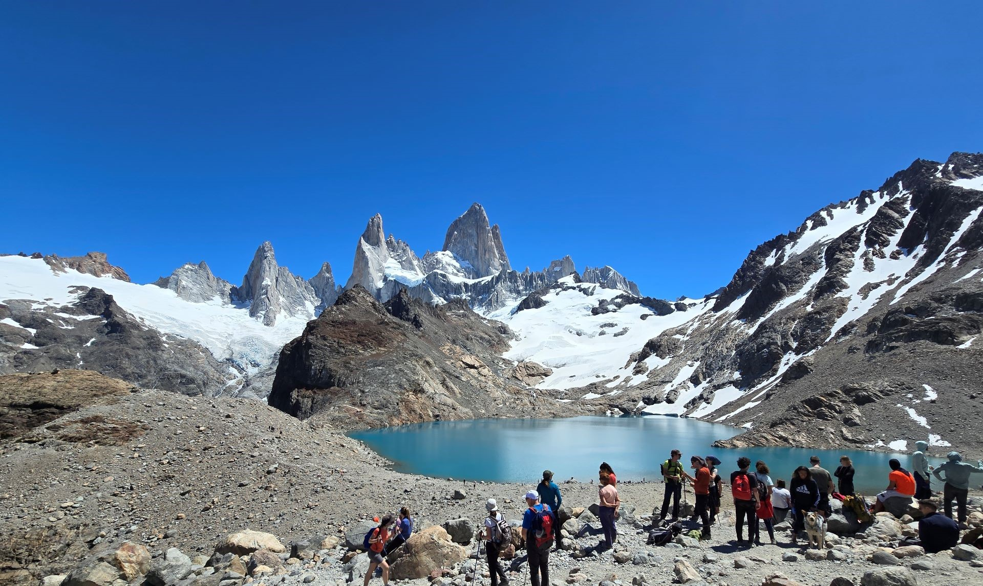
Once at the top, a short descent and final climb brought us to the breathtaking overlook of Laguna de los Tres and the towering peaks of Mount Fitz Roy, a sight that made every tough step worth it.
It took us about 1 hour to reach the summit of this section.

Exhausted, but the lagoon and Mount Fitz Roy behind makes it all worthy
We learned from other hikers that it could take anywhere from 45 minutes to 2 hours, depending on fitness and experience. The effort was grueling, but the views kept us motivated.
Once at the top, a short descent and final climb brought us to the breathtaking overlook of Laguna de los Tres and the towering peaks of Mount Fitz Roy, a sight that made every tough step worth it. We sat down and enjoyed our sandwiches with this stunning view, and at that moment, all our exhaustion faded away. We went down to the lagoon with its aquamarine water and walked around it. We spent about 30 minutes soaking in the scenery before beginning the descent.
Essential Tips and Preparation for Hiking Laguna de los Tres
Before you set out on this incredible hike, here are some important things we learned from our experience that can help you prepare and enjoy the journey even more.
Nearest Airport
The nearest airport is Comandante Armando Tola International Airport in El Calafate, located 137 miles from El Chalten. There are no airports in El Chalten and you can rent a car at the El Calafate Airport.
Timing and Where to Stay
We stayed in El Calafate, which is closer to the famous Perito Moreno Glacier, great if you want easy access to the glacier and the town’s amenities. However, if you plan to do both the Laguna de los Tres hike and the Perito Moreno Glacier trek, it’s smarter to stay in El Chalten for the hike. You can then take a rest day before driving back to El Calafate in the evening to do the glacier trek on the third day. This way, you avoid a long same-day drive and give your body some time to recover between two physically demanding adventures.
Start Early
We began our hike at 9 AM after driving three hours from El Calafate that same morning. By the time we finished at 6 PM, we were exhausted and feeling the effects of the heat. Looking back, starting that late wasn’t ideal. The best advice? Drive to El Chalten the night before if you can, and start hiking early, around 6 AM if possible. The sun is intense, and starting early means you can enjoy cooler temperatures and take your time without rushing.
Tickets and Regulations
You need tickets to hike in this national park. Keep in mind that rental cars in El Calafate are limited, especially in high season, so if driving is an issue for you, you can buy your tickets for Laguna de los Tres hike here. They offer tours with transportation and national park tickets included, which makes the trip much easier.
Distance and Difficulty
Officially, the hike is listed as around 22-24 km round trip. But here’s a surprise, all our step trackers showed a whopping 34 km! We didn’t take any detours, so be prepared for a longer, tougher hike than expected. The first part is a steady climb followed by a mostly flat stretch, but the last 2 km are a steep, exposed mountain face without a marked trail, requiring careful footing and good stamina.
Facilities
Water sources are there. But you won’t reach any glacier streams until about 1.5 hours into the hike, and these streams disappear roughly 1 hours before the end. This means you need to carry enough water to last you 2 to 2.5 hours at both the start and the end of the trail. We refilled our bottles twice along the way, which helped a lot
One thing to know: there are no toilets available on the trail. So, be prepared to manage without facilities for the entire day.
Gear and Safety
Good hiking boots with strong grip are a must, especially for that final rocky climb. Trekking poles can be a big help for balance and to take some pressure off your knees on the steep sections. Don’t forget sun protection: a wide-brimmed hat, sunscreen, and sunglasses are essential since most of the trail is exposed to the sun after the initial shaded section.
Alternative: The 2-Day Hike
If you want a more relaxed experience, there’s also a popular 2-day option for Laguna de los Tres. You can camp overnight at Poincenot Campground, which is close to the lagoon and lets you catch the stunning sunrise over Mount Fitz Roy. The campground has basic facilities, dry toilets and potable running water from a nearby stream, but be aware these campsites must be reserved and paid for ahead of time. Some hikers camp mid-way in the forest where there’s a camping site, but washroom facilities there aren’t always usable.
Despite the challenges, this hike is one of the most rewarding experiences in Patagonia. With the right preparation and an early start, you’ll be set to enjoy one of the most spectacular mountain landscapes in the world.
Leave a Reply