Hike the Table Mountain – Platteklip Gorge trail
Table Mountain is 1,086 meters (3,563 feet) above sea level. The flat-topped peak is a prominent landmark in Cape Town, and its elevation is the highest point of the Table Mountain National Park.
We started our hike early in the morning. It was August, and the rainy season hadn’t ended yet. We had originally planned to start the hike at 6 AM, but due to the rain, we delayed our start to 7 AM, which actually turned out to be perfect weather.

Table Mountain – Platteklip Gorge Trail
We chose to take Platteklip Gorge trail. The hike starts from Tafelberg Road which is the parking lot for Platteklip Gorge trail. It is about 2 kms from where cable car station going up. So we drove past the Cable Car station and went around the mountain to reach the parking lot.
The Platteklip Gorge trail is about 3.8 kms and is the shortest. Shortest so its the most steep trail.
It’s a well-structured trail, with rock steps most of the route. There are very few flatter areas and the trail goes straight up. As we started early in the morning it was still misty for a while. However we never felt it to be cold and were comfortable with our waterproof windbreakers.
The hike began with a steep climb over rock steps.
Within half an hour of our climb, we entered a shady forest filled with streams and waterfalls.

Blue Planet Travellers
Waterfalls cutting through the rocky steps of the trail
At one point, we had to step right on the top of a waterfall which was a thrilling experince.

Blue Planet Travellers
The trail to the summit of Table Mountain
It was a steep climb so we were able to get the breathtaking view of CapeTown and the Atlantic Ocean. The trail zigzagged up the mountain, so this view stayed with us until we reached the top.
It was late August and there were many groups of hikers on the trail and was very crowded.
The weather kept shifting as we climbed up and we walked through clouds that grew thicker the higher we climbed.
It rained twice, but only briefly, with light drizzles. Locals told us that no matter the season, Table Mountain always seems to have rain showers the closer we are to the summit.
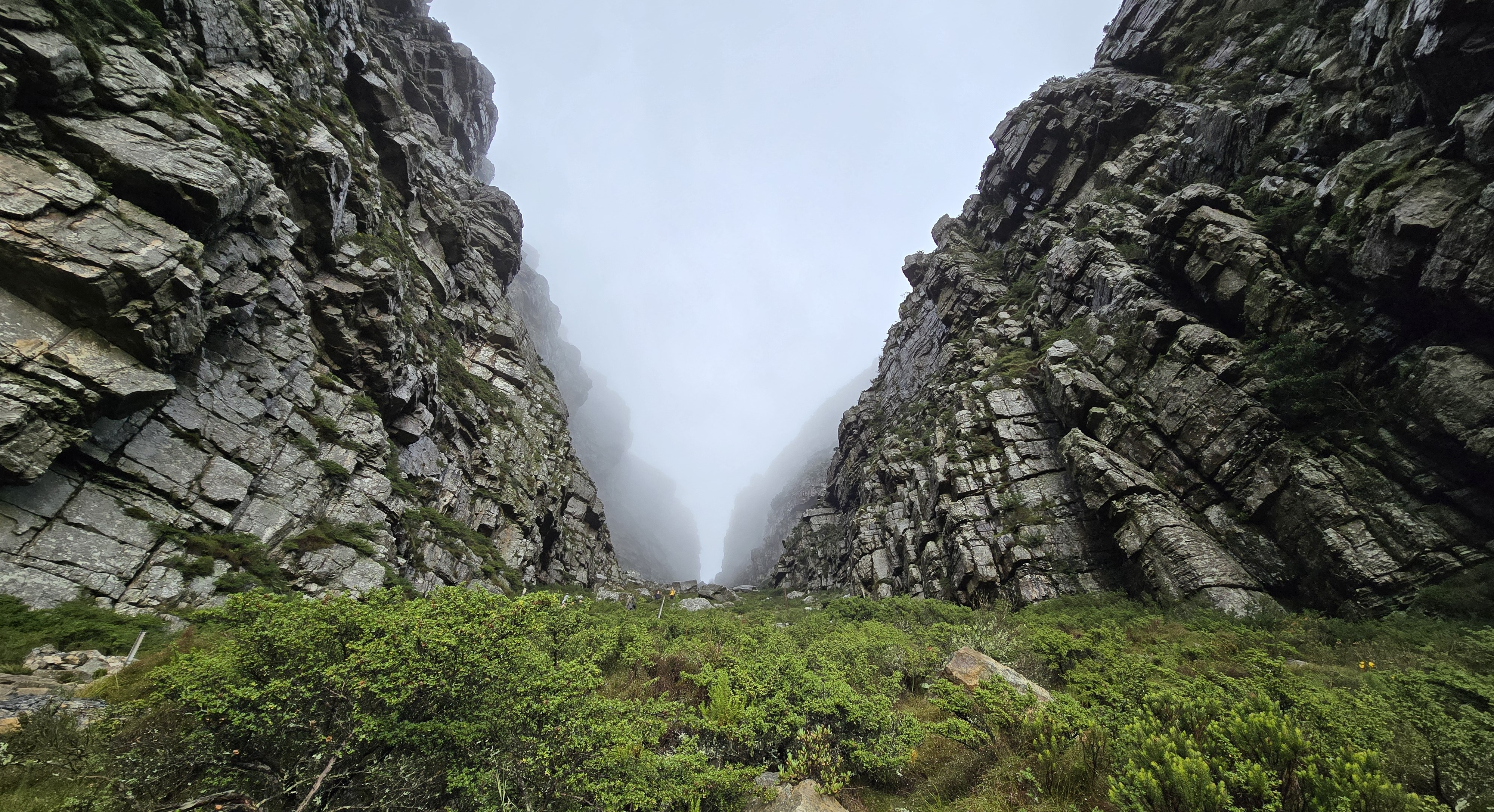
The climb was consistent uphill and was physically demanding. Further we hiked and were able to see the gorge walls above us opening to no where. From here it was just half an hour to the summit and we hiked up with the gorge view.
At this point some steps were very high, each one needed a full leg lift to climb.
As we ascended further, the gorge narrowed, with sedimented black rock walls of the cliffs on both sides almost converging at the top to create a gorgeous two metre wide pathway providing access to the summit.

At the Platteklip Gorge entrance – the trail we hiked

Blue Planet Travellers
The view from the gorge walls
The Table Mountain with its layered sedimented rocks looked absolutely beautiful. It was like layers stacked on top of each other.
Rain from the mist and clouds on the mountain top flows down through the gorge walls, forming small waterfalls along the way.
We are now almost a km above sea level and the view of the Atlantic Ocean and Captown from here was mesmerizing.
We reached the summit, took some photos, and walked around 15 minutes to enjoy the views from the back of Table Mountain.

View of Capetown and the Atlantic Ocean from top of Table Mountain
At the summit of Table Mountain, there’s a 360-degree walkway that circles the mountain, providing breathtaking views in every direction.

Blue Planet Travellers
Walking around the summit of Table Mountain.
Within minutes, clouds rolled in and completely covered the summit, leaving us with zero visibility. It seems to happen multiple times a day no matter the season.
There’s a café at the top, so we grabbed some coffee and bought our cable car tickets for the ride down.
Since the cable car rotates 360 degrees, we didn’t bother to pick a front-facing spot. On the way down, the mountain was completely covered in clouds, and we couldn’t see anything. We were glad we hiked up earlier and caught the clear views before the clouds rolled in.

Blue Planet Travellers
Walking to the cable car station to go down.
We bought our one way cable car tickets at the cable car station on the summit. There is an automated machine inside the building before we line up for the cable car.
After taking the cable car down, we turned right and walked another 2 kilometers to reach the parking lot, then drove back to Camps Bay.

Blue Planet Travellers
View of Cape Town from the cable car
Leave a Reply to Aman Cancel reply